Hiking the GR20 in Corsica
My personal experience hiking the GR20 in Corsica in August 2023 as a solo female average hiker (rather spontaneously)
I also used Komoot for the first time where you can find route details and some photos from me. Here’s the link.
- What is GR20?
- Fitness and experience required to hike the trail
- When to hike? Should I avoid the peak season?
- North to South vs South to North?
- Section hiking — which section should I hike?
- Is it easy to get off the trail?
- Is there cell phone reception?
- Who is hiking the GR20? Who did I meet on the trail?
- Language
- Accommodation (Do you bring your own tent? Should you make a reservation in advance?)
- Park owned refuges, private bergeries, hôtels & gîtes
- Food & water (How much should you bring, carry? What kind of food is available on the trail?)
- Packing (What to bring, backpack size)
- Who should hike the GR20?
- Cost breakdown (Access to the trailhead, food on the trail, accommodation)
- What would I do differently?
- Would I hike it again?
- Other trail recommendations by GR20 hikers
- Resources (books and apps)
What is GR20? #
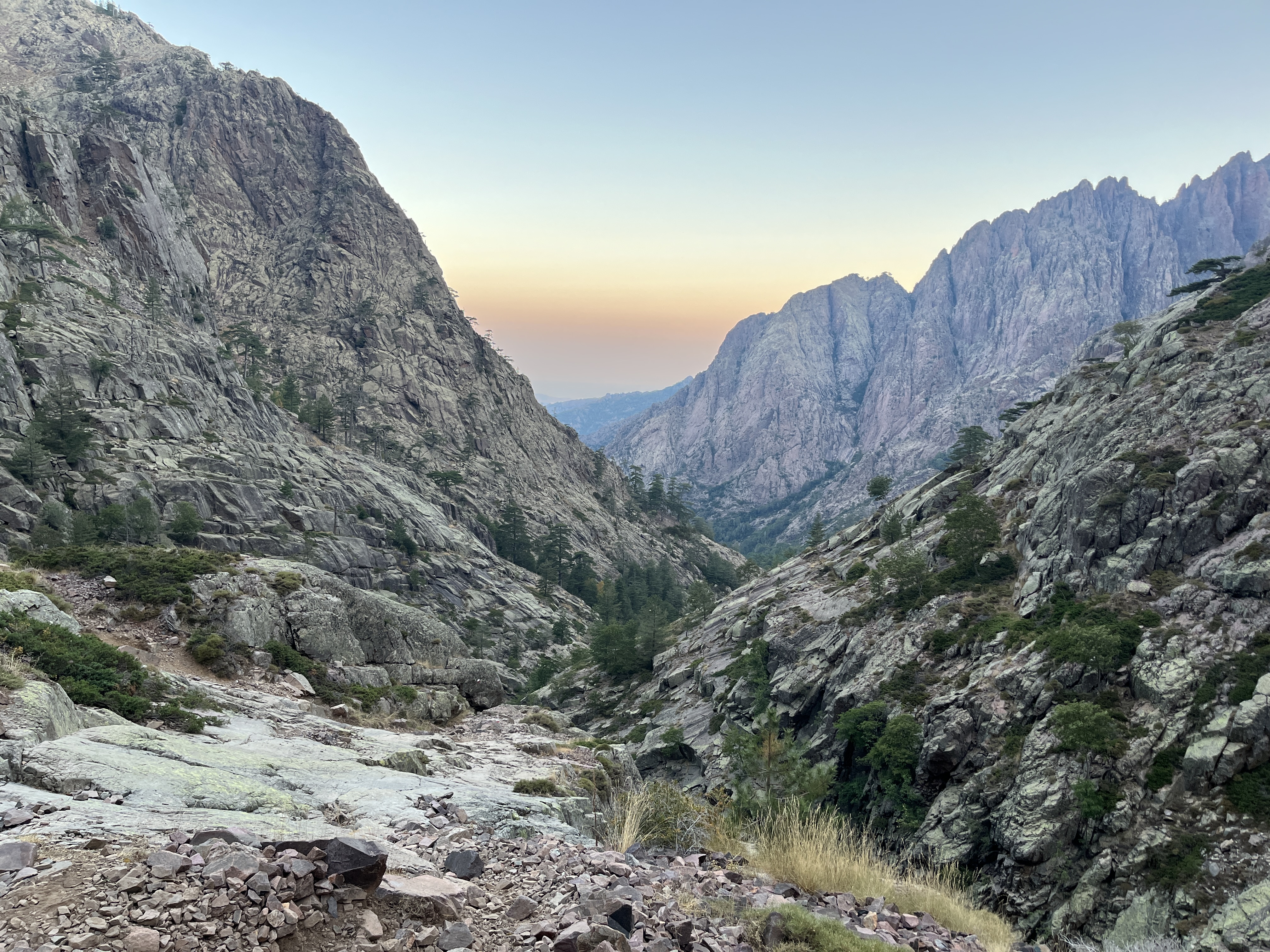
The GR 20 is a GR footpath that crosses Corsica (French island in the Mediterranean) running approximately north–south, and is around 180 km long with 12,000 m of elevation gain split into 15 stages. Many people walk the trail in about 10 - 13 days. The trail is considered to be the most difficult of all the GR routes and consists of two parts, northern and southern part.
Fitness and experience required to hike the trail #
I would say it would be good to be relatively fit and healthy (especially in the joints) but I don’t think special training is necessary. Since the trail is very very well-marked (if you don’t see a mark for more than 10m, you know you’ve gone off the trail) and it’s a popular route frequented by many hikers (sometimes overcrowded), with many water sources and well staffed refuges and huts along the way to stock up on food, it would be difficult to get lost or run out of water/food, making it a good trail for hiking beginners. There are also escape routes on almost every stage, which give you the option to drop out and get off the trail if something goes wrong.
I felt safe hiking the trail alone because I knew that I would never really be alone and there would always be other hikers in case of emergencies. I think it’s a great route for those who are not necessarily experienced in hiking but want a physical challenge.
When to hike? Should I avoid the peak season? #
I was initially worried about how crowded the trail was going to be during the peak season in mid-August but it was actually ok (although someone told me that there are 40% less hikers this year) It was enough people to not feel too lonely on the trail but not too many that I felt overwhelmed. The weather was very stable and sunny during the 2 weeks I was in Corsica which is great because I don’t think I would’ve walked the stages 2 to 4 if it was raining. The rocky paths would’ve been too slippery.
BUT it was VERY HOT — so hot in fact that it was difficult to walk during the day after lunch. So on most days, everybody started walking while it was still dark outside. A head lamp is a must-have. I woke up around 4 or 5 on most days and started hiking by 6:30 the latest. I hiked in the afternoon on the first day from Calenzana to Refuge d’Ortu di u Piobbu which was the worst mistake ever. I almost had a heat stroke. If you’re going during the summer, don’t start hiking in the afternoon.
North to South vs South to North? #
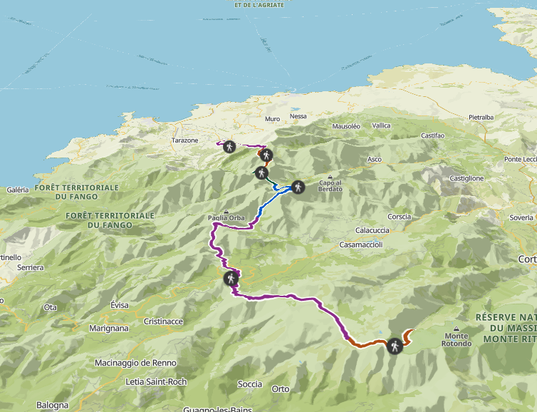
Since I only had a week to hike the GR20, I could only do a section of the GR20. I had a difficult time deciding between the north section or the south section, and whether to walk it north to south or south to north. North section is known to be more technical and physically tougher but the views more spectacular. Most people start from the north and walk south, so I decided to start from the north tip and walk south. I don’t regret this decision because I made lots of friends on the trail (when you meet the same people on the trail every evening at the refuges, or you walk pass each other on the trail several times, you start to form bonds with these people!) But I would say, I enjoyed the latter half of the north section a lot more than the first few stages. If I were to do it again, I would start from Vizavonna (the middle point between the trail) and walk northwards.
Section hiking — which section should I hike? #
I only hiked the first 6 sections of the trail (I started from Calenzanna and left the trail just after Refuge Manganu from Lac de Capitellu and hitched-hiked to Corte.) Out of the 6 sections, my favorite part was from Vallone to Ciottulu di Mori and to Manganu via Lake Nino. I especially loved the descent from Refuge Ciottulu di Mori. This section reminded me of the highlands in Scotland and you’ll love this section if you’re someone who prefers hill-walking to technical alpine climbing with lots of loose rocks and steep descents.
Is it easy to get off the trail? #
YES, this was actually one of the things that made me feel really comfortable about GR20 and hiking it alone. There were a few people who had dropped out due to sprained ankles and other injuries and there are always routes that will take you down the mountains easily.
Is there cell phone reception? #
It’s not very great. I didn’t get cell phone reception until the 3rd stage, but only briefly as well. After that, it gets a bit better. Tell your families in advance that you won’t be reachable and you’ll be ok.
Who is hiking the GR20? Who did I meet on the trail? #
I met many couples in their late 20s to mid 30s but also groups of friends from all ages. Mostly people from neighboring European countries, many from continental France. A few solo hikers too but most form groups by the first few days. I also noticed that there are usually a split between the French speaking and the non-French speaking groups. Some are more experienced than others, but I’ve met plenty who are hiking a trail like this for the first time.
Language #
Most guardians at the refuge speak English but it’s generally good to be able to speak French. Plus, you’ll make more friends that way.
Accommodation (Do you bring your own tent? Should you make a reservation in advance?) #
On GR20, you’re not allowed to wild camp wherever and it’s required that you camp at the refuges and bergeries or nearby. However, I did see some nice camping spots along the trail and met some people wild camping despite it being prohibited. I do think it’s nice to stay near the refuges and bergeries to socialize and make friends though.
Since I didn’t own a light-weight tent, I didn’t bring one with me and relied on hired tents and beds at the refuges. But from what I’ve seen, most people opted to bring their own tents. Having your own tent makes planning a lot more flexible and you’ll definitely save money. BUT, I also saw someone giving away a tent on the 2nd day because they couldn’t walk with the weight anymore. So really consider getting a lightweight tent. I also saw some people only bringing the inner tent without the outer fly since the weather forecast looked good.
So my biggest worry was this — if I don’t have a reservation, would I be able to stay at a refuge? What if I arrive at a refuge and it’s full? Well, I needn’t have worried too much. Usually, I managed to find free beds or free tents for hire on arrival. Refuges with dormitories usually had lots of free beds (I even had a whole room to myself at Refuge Asco) but some refuges don’t have dormitories but only limited number of hired tents. For example, the first refuge, Refuge d’Ortu di u Piobbu, only had 2 hired tents left when I arrived. Refuge de Tighjettu didn’t have any free tents when I arrived so I had to walk to the next bergerie (which was luckily only 45 mins walk away). If the weather is good, you could sleep just with your sleeping bag since there aren’t too many insects and animals to bother you.
Since this year (2023), we can make online reservations in advance for the refuges. In some guides, it says that it’s necessarily to book them in advance if you’re not carrying a tent. However, the reality is that you can usually find some form of accommodation somewhere as I’ve already written above. You can book them from the park’s website:
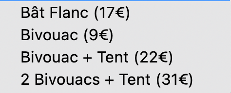
- Bat Flanc (a bed in a dormitory)
- Bivouac (staying with your own tent)
- Bivouac + Tent (tent for hire)
- Bivouac + Tent (tent for hire, for 2 people)
The reason why there are options for Bivouac + Tent and 2 Bivouacs + Tent is because the tent they rent out is usually for two people, so it’s cheaper to rent a tent as 2 people vs 1 person.
When you don’t book in advance, the costs are a lot higher:
- Bat Flanc 30€
- Bivouac 15€
- Bivouac + Tent 33€
- Bivouac + Tent 48€
The problem though, is that you never really know how far you’re able to walk until you start walking. There’s also the weather. I was lucky to have sunny days but that’s not always the case. And some sections, you would want to wait out if it rains. It is theoretically possible to change your reservation via phone or email but the problem is that you won’t necessarily have cell phone reception.
I wasted two nights worth of reservations because I couldn’t walk according to my plans. I would say maybe book the first night, but don’t bother booking the rest. And carry your tent if you can or if you can somehow split the weight load with whoever you’re hiking with. Or if it’s sunny, it’s definitely possible to just sleep with your sleeping bag and mattress.
The reservation system is a little silly in my honest opinion. It just doesn’t work and I hope they will not continue with it.
Park owned refuges, private bergeries, hôtels & gîtes #
Refuges are owned by the park, the rest are private (is my understanding.) I only stayed at one bergerie but it was a lot nicer than the refuge and cost around the same, or even less than booking a bed in a refuge. Staff at Bergerie de Ballone were super friendly and the food was amazing.
https://objectif-gr20.fr/refuges-gr20/
It’s in French but you can use a browser translator
Food & water (How much should you bring, carry? What kind of food is available on the trail?) #
There are many sources regularly spread out throughout the trail. Most of the time, you won’t have to carry more than 2L of water at any time except for maybe days you plan to do double stages or you know it’s going to be a sunny day.
Food is very available on the trail. Usually, you get a full course dinner (starter: soup with bread, main: some kind of pasta, dessert: cheese or cake) for 20€ and a simple breakfast (coffee or tea, bread jam and butter) for 10€ and packed lunch (usually sandwich) for 10€. There are also snacks, cereal bars, dried fruits, beers and other alcoholic and non-alcoholic beverages, other meals for 10€.
You would usually need to reserve dinners upon arrival and they are usually at around 6 or 7pm. I highly recommend reserving these and eating these dinners not just for the food but to meet people and socialize. It was one of the fun part about the GR20 compared to other lesser known hikes I’ve done in the past.
Packing (What to bring, backpack size) #
Honestly, 30L - 45L (max!) Should be less than 10kg including water. Keep it SUPER minimal. I only wore one T-shirt (merino wool is amazing) and one pair of shorts during the whole week (it will dry within a few hours if it’s sunny) but maybe bring a pair of thermal long sleeves and a fleece or a down jacket for cold nights. You don’t need a full size towel, just bring a small one. You don’t need a cooker (all refuges have cookers, stoves, even cutlery)
WHAT TO BRING 👇
CASH! You run out of cash, you’re done on GR20. You pay everything with cash on the trail. Hiking sticks, they are a must-have or you’ll really hurt your joints. Headlamps, if you don’t want to walk in the scorching heat during the day. Toilet paper, definitely a full roll. Elastic tapes to support your ankles, knees and other joints. Hydration packs so you don’t have to stop every time you want to hydrate.
Good to haves — Maybe coffee? (I did miss my morning coffee very bad) I was glad I brought a bag of muesli (saved me breakfast cost) and wished I had brought more healthy snacks (nuts and dried fruits) with me.
Who should hike the GR20? #
It’s super popular but maybe too touristy for more seasoned hikers or those who want silence and solitude, especially during the summer peak season. But as someone a little anxious about hiking solo, I felt safe and never alone which was nice. I heard that the trail is a different place in the winter when there’s snow and the huts are unmanned so if you want to experience solitude, maybe pick a different time of the year?
Even though it wasn’t physically an easy trail to hike, especially on the joints, it’s very VERY well-marked meaning I didn’t have to worry about getting lost. In that sense, it was an easy hike perfect for beginners. It’s also relatively short (2 weeks) which is a good length to get started or to try it out during a vacation.
Also, even if the weather turns bad and/or you’re not able to continue with the hike, the island offers so many other attractions that you can always change plans to go canyoning, kayaking, climbing or even just spending a day on the beach chilling.
Cost breakdown (Access to the trailhead, food on the trail, accommodation) #
- Bastia to Calvi: around 10€ by train (but hitchhiking apparently works really well in Corsica)
- Calvi to Calenzanna: 9€ by bus that goes twice daily. Apparently taxi costs around 40€, so considering splitting costs by gathering other people.
- Food: 30-40€/ day (I usually ate dinner at the refuge, cooked my own breakfast and snacked for lunch)
- Accommodation: 30€/day average. I preferred hired tents to sleeping in dorms, I slept better. Next time I would bring my own tent.
What would I do differently? #
I’d bring my own tent and opt for shoes with more ankle support considering my history of sprained ankles. I would bring more snacks, no cooking equipment and less clothes. Maybe a smaller sleeping bag and better hiking poles. I would NOT start hiking in the afternoon on a summer day. I wish I had a few more days so I could reach at least Vizzavona (end of the first half of GR20.)
Would I hike it again? #
Yes!
Other trail recommendations by GR20 hikers #
- GR738
- GR51
Resources (books and apps) #
These offline maps and guides have been super useful!
- Komoot (offline map)
- Google satellite imagery map (offline map)
- Maps.me (offline map)
- GR20 app
- Trekking the GR20 Corsica by Paddy Dillon (kindle)